
 The Mississippi River brings much sediment to the deltaic region of southeastern Louisiana, yet the marshes there have been disappearing since the mid-1900s. A number of factors contribute to the wetland loss, including the current position of the delta in deep water and levees that reduce the frequency of over bank flow and corresponding sedimentation. Recent engineering strategies to restore coastal wetlands include creating breaks in levees and uncontrolled diversions in order to release fresh water and/or sediments into the wetlands. It holds promise for areas close to the river where sediment (as opposed to only fresh water) is released and where conditions in the restoration area are suitable (Mossa 1996).
This image is a simulation of the natural environment and is not an accurate representation of "true-color" as perceived by humans. This satellite image of Louisiana was produced from 30-meter resolution TM imagery, acquired between November 1992 and March 1993. These data were geo-rectified and resampled to 25-meter cells by the Earth Observation Satellite Corporation (EOSAT). The image is a composite of Landsat TM band 7, mid-infrared, band 5, near-infrared, and band 3, red-visible light (Louisiana Oil Spill Contingency Map CD 1996).
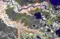 The natural levees of the Mississippi River and its abandoned courses show where the vegetation has been removed and humans have settled on this relatively higher ground. At a distance from the active and abandoned Missisippi River courses are interdistributary basins. Given the distance from the active and abandoned courses, these areas tend to have more lakes and are more low-lying and distant from fresh water and sediment, therefore generally more vulnerable to land loss.
This image is a simulation of the natural environment and is not an accurate representation of "true-color" as perceived by humans. This satellite image of Louisiana was produced from 30-meter resolution TM imagery, acquired between November 1992 and March 1993. These data were geo-rectified and resampled to 25-meter cells by the Earth Observation Satellite Corporation (EOSAT). The image is a composite of Landsat TM band 7, mid-infrared, band 5, near-infrared, and band 3, red-visible light (Louisiana Oil Spill Contingency Map CD 1996).
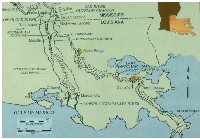
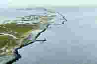
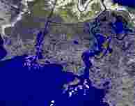 In south-central Louisiana, the Lower Atchafalaya River and a local diversion through the Wax Lake Outlet have deltas that have grown during the last few decades in Atchafalaya Bay. This is one of the few areas of land gain in southern Louisiana. Controlled diversions from the Mississippi River near Old River and the entirety of the Red River combine to form the Atchafalaya River.
This image is a simulation of the natural environment and is not an accurate representation of "true-color" as perceived by humans. This satellite image of Louisiana was produced from 30-meter resolution TM imagery, acquired between November 1992 and March 1993. These data were geo-rectified and resampled to 25-meter cells by the Earth Observation Satellite Corporation (EOSAT). The image is a composite of Landsat TM band 7, mid-infrared, band 5, near-infrared, and band 3, red-visible light (Louisiana Oil Spill Contingency Map CD 1996).
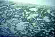
 This infrared photograph shows the fragile back barrier marshes of the Chandeleur Islands of southeastern Louisiana. Frequent overwashing has flattened the barrier surface and left a nearly continuous series of washover fans.
 A more detailed look at the fragile back barrier marshes of the Chandeleur Islands of southeastern Louisiana shows a number of wetland lakes of various sizes and forms and minor channels. Being unoccupied, the island morphology shows no evidence of human impact.
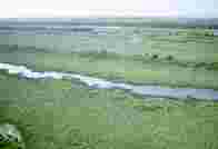
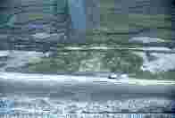
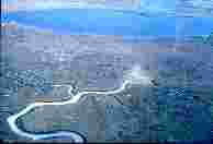 Some inland marshes in the vicinity of the Lake Pontchartrain basin of southeastern Louisiana show a much larger marsh area. The surface is still vulnerable to human impact, manifest by the marsh buggy tracks that remain visible for decades across the marsh surface.
 The chenier plain of southwestern Louisiana has a very different geomorphology than southeastern Louisiana. There are cheniers, or oak-covered ridges of sand and shell, interspersed with mudflats, marshes, or long linear lakes. A couple of shore-parallel ridges are shown here. There is generally less land loss in the chenier plain than the delta plain, and much of it is also associated with human impacts.
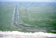
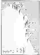
 Across much of south Louisiana, artificial levees have been built on top of natural levees or around other areas that are considered vulnerable to flood waters. This slide shows the general extent of areas bordered or surrounded by artificial levees, although there are several levees not shown at this scale. In some areas where levees are not present, the river is bordered by high bluffs. Where pairs of levees occur generally perpendicular to the river, these are floodways designed to divert water away from cities and towns along Mississippi. Examples include the Morganza floodway, which sends water into the Atchafalaya basin, and the Bonnet Carret Floodway which sends water into the Pontchartrain basin. In other cases, there is an outer set of parallel levees at a distance from the inner set.
 In other areas, such as around Morgan City on the Lower Atchafalaya River, a concrete floodwall has been built for a similar purpose. However, in addition to keeping out water during floods, the flood walls and artificial levees prevent sediments from depositing adjacent to the river and helping build up low-lying areas.
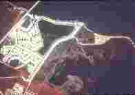
 Smaller artificial levees have been built by landowners for "land reclamation", in this case conversion of marshes to agricultural land (sugar cane), in combination with drainage. The marshes tend to subside when drained because the organic-rich materials become oxidized. Over time, they may lower several meters in elevation. This aerial infrared photograph shows one successful attempt at this type of reclamation and one failure. The rectangular area to the north is has been converted and is used for growing sugar cane. In the rectangular area to the south, the levees were broken and water filled the relatively low-lying area to form a permanent rectangular lake.
 A very different form of reclamation is building a series of canals or "finger-island developments" in low-lying marshes created by dredging and filling. This area is known as Eden Isles (1978 infrared photograph) and lies on the shore of Lake Pontchartrain, an area with a very low tidal range. Tides help in flushing these canals, and a higher tidal range is thus more desirable for areas with septic tanks. The organic-rich soils have also subsided and some structures have problems with differential subsidence
 Building roads for access across the Louisiana marsh creates land loss and other environmental damages. To build this road required obtaining fill from the adjoining areas. There are a series of alternating "borrow pits" on both sides of the roadway.
 In an effort to combat or control land loss, structures of various kinds have been built. Many of the interior marshlands in southern Louisiana have structures such as weirs and flap gates made to keep out saline water or manage the land for a particular purpose. Shown here is a double flap-gated variable crest weir in southeastern Louisiana. One problem is that when water inflow is minimized, so is sediment input. As a result, these areas also continue to be vulnerable to land loss.
 There are a lot of petroleum facilities on the barrier islands and headlands to support onshore and offshore drilling activities. A rubble-mound revetment and T-groins were placed with the intent to protect facilities on East Timbalier Island and reduce shoreline erosion. Several hurricanes have moved the rocks, the island continues to subside and move inland, and it appears the structure is useless. Erosion and subsidence continue nonetheless.
 A cement-bag seawall was used to protect petroleum facilities and reduce shoreline erosion on the Bayou Lafourche headland. Several hundred thousand cubic yards of sand, dredged from a nearby bayou and navigation channel, were used to renourish the beach and to build up the area behind the seawall. The area has been battered by several hurricanes since and has very little beach remaining in front of it (Mossa and Nakashima 1989; Nakashima and Mossa 1991).
 The "Big Bend" area of Florida on the Gulf of Mexico is underlain by limestone and is not vulnerable to subsidence like the marshes of Louisiana. Therefore within the Gulf it has a comparatively low rate of relative sea level rise (Gornitz et al. 1994). It has also been labeled a "zero energy coast" (Tanner, 1960) and is generally not vulnerable to wave attack. However, the area is fronted by a wide, shallow continental shelf and the shoreline configuration forms a pocket that funnels water pushed onshore by wind, resulting in very large storm surges. It has been estimated that if a Category 5 hurricane were to strike this area directly, the estimated storm surge would be 9.8 m (Fernald and Purdum 1992). This slide shows storm surges associated with a much smaller storm in March 1993. Although it was much less than the calculated 100-yr or Category 5 storm surge height, it did cause extensive damage.
Some locations had storm surges about 4 m above normal high water.
The area struck in the following sequence of slides experienced a storm surge of about 3-m in March 1993.
The "Big Bend" area of Florida on the Gulf of Mexico is underlain by limestone and is not vulnerable to subsidence like the marshes of Louisiana. Therefore within the Gulf it has a comparatively low rate of relative sea level rise (Gornitz et al. 1994). It has also been labeled a "zero energy coast" (Tanner, 1960) and is generally not vulnerable to wave attack. However, the area is fronted by a wide, shallow continental shelf and the shoreline configuration forms a pocket that funnels water pushed onshore by wind, resulting in very large storm surges. It has been estimated that if a Category 5 hurricane were to strike this area directly, the estimated storm surge would be 9.8 m (Fernald and Purdum 1992). This slide shows storm surges associated with a much smaller storm in March 1993. Although it was much less than the calculated 100-yr or Category 5 storm surge height, it did cause extensive damage.
Some locations had storm surges about 4 m above normal high water.
The area struck in the following sequence of slides experienced a storm surge of about 3-m in March 1993.
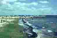 The coastline around Dekle Beach does not have much sand, and limestone is at or close to the surface. Wave heights are low. The recent storm has left a ridge of organic debris along the edge of the coast.
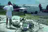
 Huxford Haven, the name of a house, may have once been a haven, but not after the 1993 storm. What remains is just woodwork that supported this structure in Dekle Beach.
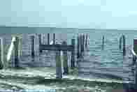
 What used to be a public toilet is now all too public! The surge associated with the March 1993 storm removed the walls of this bathroom at Keaton Beach, in the Florida Big Bend area.
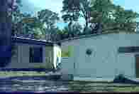 These checkmarks were common on buildings inspected by FEMA following the March 12-13 1993 storm. Ten lives were lost, 57 residences in Dekle Beach and Keaton Beach were destroyed, and property damages were in excess of $2 million (Natural Disaster Survey Team 1994). This area has been characterized has having relatively low vulnerability, and reasons for this include low coastal erosion rates because of limestone near the surface and low wave energy. Given this example with a relatively minor storm and accompanying surge, would you call this area vulnerable or not?
Gornitz, V.M., Daniels, R.C., White, T.W., and Birdwell, K.R. 1994. The development of a coastal risk assessment database: Vulnerability to sea-level rise in the U.S. southeast. Journal of Coastal Research Special Issue No. 12, Coastal Hazards, pp. 327-38.
Louisiana Oil Spill Coordinator. 1996. Louisiana Oil Spill Contingency Map CD. Office of the Governor in cooperation with Louisiana State University, Department of Geography and Anthropology.
Mossa, J. 1996. Sediment dynamics of the lowermost Mississippi River. Engineering Geology, v. 45, pp. 457-79.
Mossa, J., and Nakashima, L.D. 1989. Changes along a seawall and natural beaches: Fourchon, Louisiana. Coastal Zone '89 - Proceedings of the Sixth Symposium on Coastal and Ocean Management, American Society of Civil Engineers, pp. 3723-37.
Nakashima, L.D., and Mossa, J. 1991. Responses of natural and seawall-backed beaches to recent hurricanes on the Bayou Lafourche headland, Louisiana. Zeitschrift für Geomorphologie, v. 35(2), pp. 239-56.
Natural Disaster Survey Team. 1994. Superstorm of March 1993-March 12-14, 1993. U.S. Department of Commerce, National Oceanic and Atmospheric Administration, Washington, DC.
Tanner, W.F. 1960. Florida coastal classification. Transactions of the Gulf Coast Association of Geological Societies, v. 10, pp. 259-66.